Civil War Maps at Printed & Manuscript Americana Auction
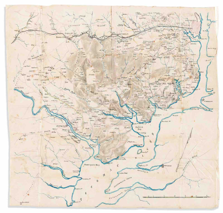
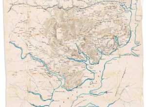
Union-drawn manuscript map of the area southwest of Alexandria, circa September 1861


A number of civil war maps go under the hammer at Swann Galleries tomorrow in its Printed & Manuscript Americana sale.
Leading the lots is a Union-drawn manuscript map of the Virginia countryside southwest of Alexandria very early in the war, around September 1861, shortly after the July 1861 defeat at the Battle of Bull Run (estimate: $3,000 - $4,000). It indicates the increasingly fortified and contested territory east of the battle site and southwest of Alexandria, with a ring of forts around Alexandria.
Other cartographic highlights include:
- an 1863 manuscript map of a failed naval expedition from St. George's Sound to Ochlockonee Bay in Florida, March 20-27, led by Acting Master Richard J. Hoffner of the USS Amanda (estimate: $800 - $1,200)
- a map of the City of Richmond, Virginia, 1864 (estimate: $800 - $1,200) from lithographers H. Lindenkohl and Charles G. Krebs, from the personal and military papers of General John Gross Barnard (1815-1882), the chief engineer under General Grant from the Siege of Petersburg through Appomattox and the end of the war
- an 1865 map of Middle Virginia and North Carolina (estimate: $600 - $900) by Charles G. Krebs after H. Lindenkohl, prepared by Union cartographers, possibly for the siege of Petersburg and final assault on Richmond, tracing the Confederate supply and retreat routes to Danville and the western mountains
The auction will also feature a 1776 diary by Benjamin Beal, an officer from the Revolution who traces the journey north to reinforce the Invasion of Quebec then meets the retreating patriot army suffering from a smallpox epidemic, plus a number of scarce and important early American pamphlets including Benjamin Rush's 1772 Sermons to Gentlemen upon Temperance and Exercise which features the first American discussion of golf.