New Exhibition Focuses on Secret Maps
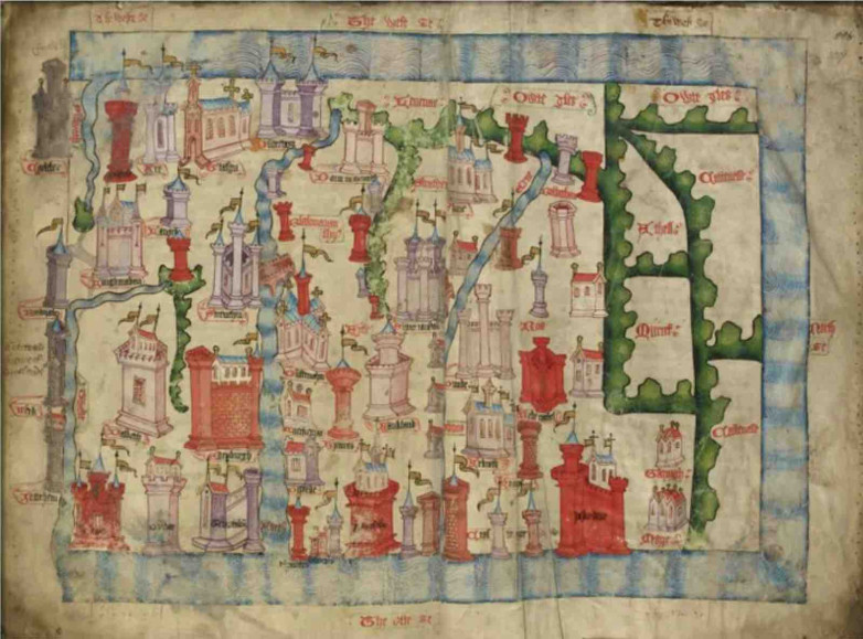
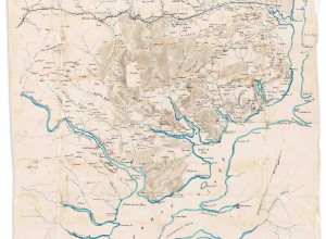
Map of Scotland from Chronicle of the History of Britain by John Hardyng, England, 1457


The use of maps by governments as confidential tools of control is at the centre of a new exhibition at the British Library in London which also looks at mapping in the Where’s Waldo? books and world-building games like Minecraft.
Running through January 18, 2026, Secret Maps begins by examining how maps enabled colonising powers from western Europe to conquer and control. Highlights include maps:
- from 1596 attributed to Sir Walter Raleigh on an expedition in what is now Guyana in South America in search of the mythical city of El Dorado
- used by British diplomats at the negotiations after the American War of Independence in 1783 outlining proposed borders between what would become the British Dominion of Canada and the United States of America
- produced in 1946 of British India (modern-day India, Pakistan and Bangladesh) with a ‘top secret’ report investigating the potential economic and military impact of partition for the proposed state of Pakistan
- of Aotearoa (New Zealand) drawn in 1793 by Māori chief Tuki te Terenui Whare Pirau highlighting the gulf between the attitudes of colonialists to ‘new lands’ and the beliefs of the Indigenous people
The second section, 'State Secrets', shows how maps from the 16th century to the present day have been used by governments to conceal strategically important information and to consolidate power. This features one of only two known existing copies of a secret map produced by Ordnance Survey during the General Strike of 1926 amid fears of a public uprising. Also on display are:
- Willem Blaeu’s globe which depicts the Le Maire Strait, a Pacific passage first charted in 1616 that the Dutch East India Company sought to keep secret to protect its trade monopoly
- a hairbrush containing escape maps sent to WWII prisoner of war camps in Germany
- a map drawn by T.E. Lawrence aka ‘Lawrence of Arabia’ depicting his journey in 1917 from the Red Sea coast to the Hejaz Railway used by the War Office to update their map of the region
'Secrets in Society' is the third section and shows how maps also reflect the values and priorities of the society for which they are created. This includes maps commissioned by governments and organisations as well as marginalised communities seeking to record their experiences, such as a 16th century 'khipu' record-keeping device created by the Inkas (Incas) which was used to map sacred landscapes in the Andes. Also on display is a copy of the London 'Gay to Z' from the mid-1970s which documented gay friendly venues in the city, and an apartheid-era road atlas of South Africa that only displays towns and cities with white populations.
The final section 'Personal Secrets' focuses on the power of mapping data. On show are land surveys used by imperial powers to confiscate and re-distribute land for colonial settlers in Ireland and British East Africa (modern-day Kenya), and a Cable Map of the World from 1927 which reveals a global network of censorship stations used by the British government to intercept messages sent via submarine and overland cables.
"Mapping over the centuries has responded to the human desire to explore and define our world but can also be used as a tool of concealment," said Tom Harper, Lead Curator of Antiquarian Maps at the British Library. "Through atlases, globes and charts in the British Library’s collection and special loans from GCHQ, the Imperial War Museum, the British Museum and other lenders, the exhibition takes visitors on a journey through the history of secrecy in cartography. Secret Maps explores how maps reflect social change, geo-politics and advances in technology while also inviting visitors to discover how often maps conceal as much as they reveal."